
The Location and Position of Laci's Body
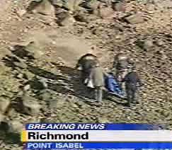
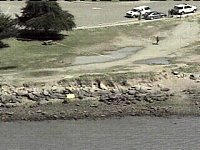
On the morning of April 14, 2003, Alena Gonzalez, her sister, and her father were walking their dogs at the Point Isabel dog park. Two of their dogs broke away from them and found something down among the riprap. Alena at first thought it was a dead animal, then discovered it was a human body. The human body was later determined by DNA to be Laci Peterson.
Since Conner did not wash ashore, we know that Scott Peterson did not put a pregnant Laci into the Bay on December 24, 2002. How, then, did Laci get to where she was found? It stretches the imagination too much to believe that Laci just happened to wash ashore on the day after Conner's body was placed on the Richmond Jetty. The logical conclusion is that the two bodies were found on subsequent days because they both were placed to be found.
With Conner, we know that he was placed in the exact location he was found. With Laci, that wasn't necessarily the case. She could have been put into the water at Point Isabel, and allowed to wash ashore. It wouldn't matter where she washed ashore, as anywhere in that general area would incriminate Scott Peterson because of his fishing trip on December 24. The other possibility is that she, too, was placed exactly where she was found.
Evidence collected to date fails to prove conclusively which scenario happened. However, the more likely scenario is that Laci was put into the Hoffman Channel during ebb tide the night of April 12/13, expecting that she would wash ashore nearby. When her body didn't surface with the high tide on the morning of the 13th, Conner was placed on the Jetty so he would be found in a way that would not risk his body also being lost. Then, unexpectedly, Laci did wash ashore on the morning of the 14th.
Point Isabel General Information
Water Levels and Wind Conditions on April 13-14, 2003
Low Tides on April 13-14, 2003
Point Isabel General Information & Layout
This information is borrowed from Wikipedia:
Point Isabel Regional Shoreline in Richmond, California, operated by East Bay Regional Park District, is the largest off-leash dog park in the United States. Point Isabel is an award-winning park offering activities for humans as well as dogs. It also features a concession offering food for humans and grooming for pets. It has easy access for pedestrians, public transit, and private vehicles.
The 23-acre park was acquired by the East Bay Regional Parks District in 1975 from the United States Postal Service which operates a large bulk mail facility there. The USPS offered to lease the land free of charge to the EBRPD until 2025 as a form of mitigation for the construction of their facility adjacent to the then-future shoreline park. The lease came with the condition of free public access.
The park, which receives over 500,000 canine visitors per year, was named the number one dog park by People for the Ethical Treatment of Animals (PETA) in 2006.
The park is open between 5 am and 10 pm PST; admission and parking are free, as stipulated by the lease agreement.[2][8] The park is fully wheelchair accessible.[2]
During off-hours,
access to the Park is not restricted.
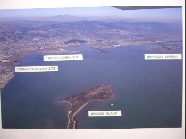
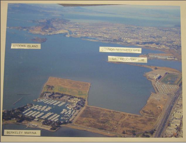
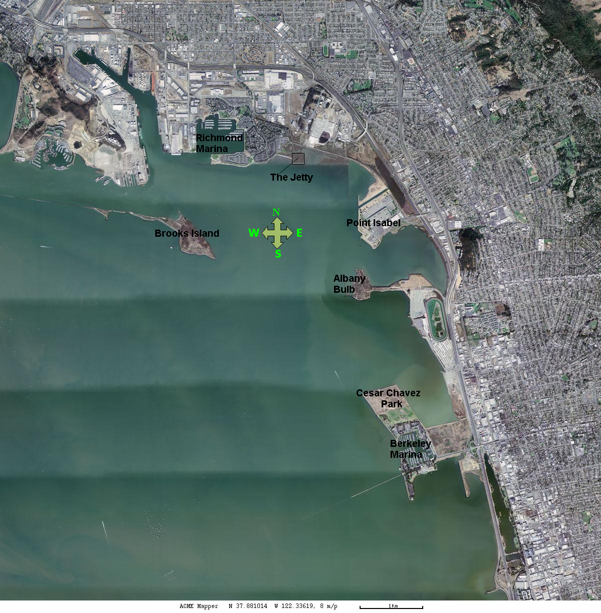
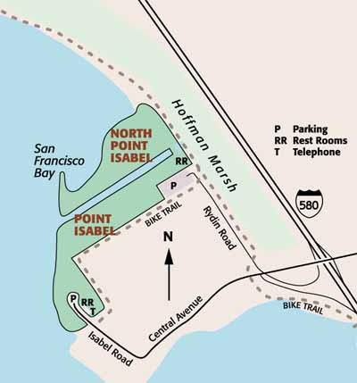
People's 97A-B shows Point Isabel's location in relation to other key sites, and
People's 98B shows the layout. In 98B, you can see the USPS bulk mail
facility, with all of its truck parking. I include an aerial photo to show
the correct directional orientation, and a graphic that shows the layout.
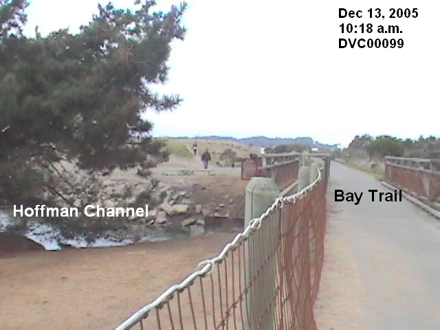
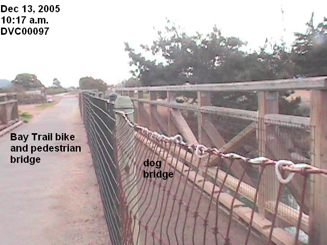
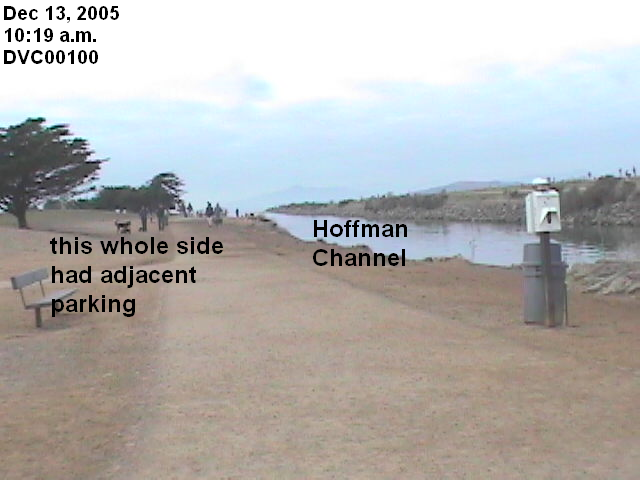
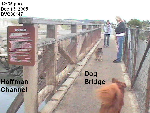
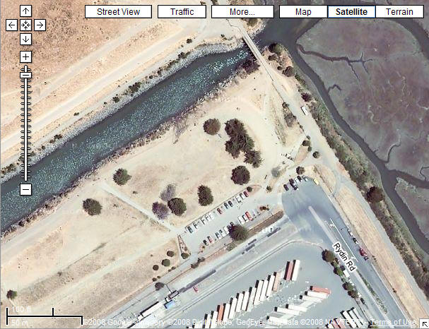
These 5 pictures of the Hoffman Channel show how easily accessible it is around the clock. The Google aerial shows where Rydin Road ends with public parking, very close to the Channel (click to enlarge). The Bay Trail bridge over the Hoffman Channel has a dog bridge on each side. Either dog bridge would accommodate a person carrying a body the size of Laci.
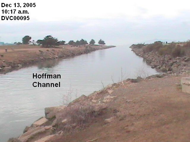
The tide rises and falls in the Hoffman Channel just as it does in the Bay. This picture was taken more than two hours after the above pictures, and after the tide had fallen from 5.75 feet to 4.40 feet. The dark coloring on the rocks indicates the water line mark for the high tide, which reached 6.74 feet.
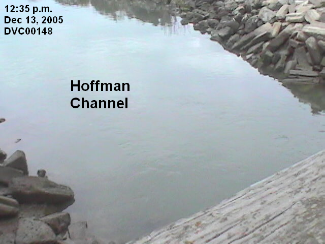
A body put into the Hoffman Channel at ebb tide would be washed back out into the Bay. Then the next high tide would bring it back in to shore.
The different locations for the bodies is one factor that favors Laci being put into the Hoffman Channel and allowed to wash ashore. One theory is that Laci's body was first put into the Channel during the night of the 12th/13th, but her body didn't surface as expected during the high tide on the morning of the 13th. Fearing Laci was lost, and thus Scott Peterson would not be convicted, Conner's body was placed on the Richmond Jetty, to protect the body from being lost and yet ensure that everyone would assume he washed ashore. Then, Laci's body surfaced the next day.
Exact location where Laci was found
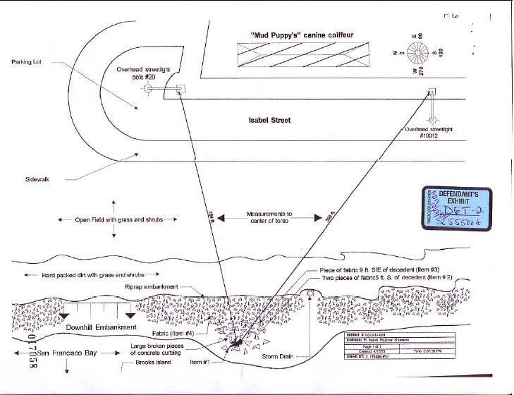
To determine whether Laci washed ashore or was placed where she was found, we must identify her exact location. Defense 6T-2 shows the exact location of Laci's body, but was pretty much useless to us.
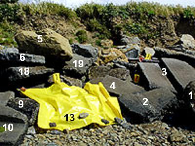
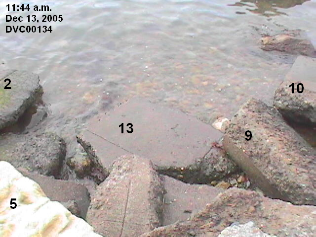
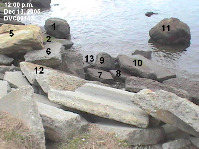
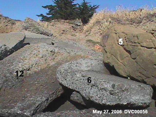
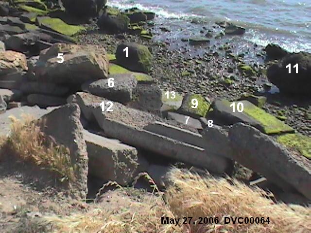
Instead, we used pictures from various media sources to identify the group of rocks where she was found, several of which are very distinctive. I've edited the pictures to assign numbers to the distinctive rocks, and put alongside the pictures some of my own pictures, with the same rocks identified. This ensures that the exact location is properly identified. Click to enlarge the pictures. More pictures from various angles and at various water levels can be seen on the December 13, 2005 and the May 27, 2006 field trips.
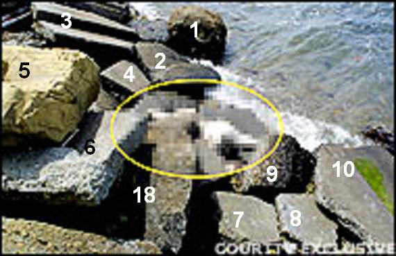

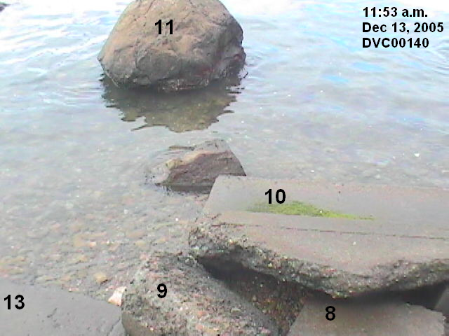
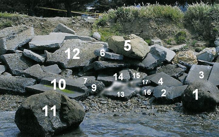
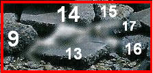
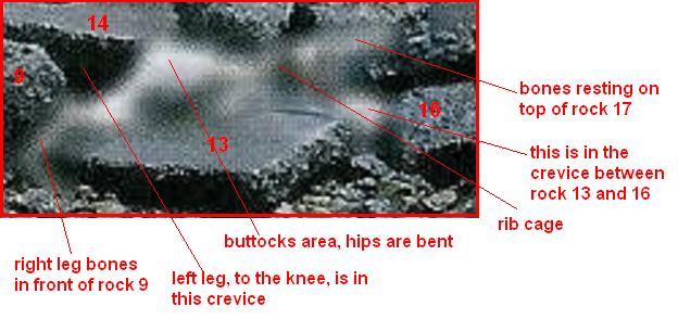
We have a picture that shows the position of her body on the rocks. In the picture, her body has been intentionally blurred, but is still distinguishable. The smaller section more clearly shows the body as it lay on the rocks. She is pushed up against rock #14. Her left leg is in the crevice formed by rocks 9, 13, and 14. Her right leg extends down in front of rock 9. The large white area just below the number 14 is her buttocks. Her rib cage is shown by the darkish area, and the long white streak on top of rock 17 is bones, either her upper spinal cord or an arm.
This is my interpretation of how Laci's body was positioned.
These pictures show the crevices between the rocks. The
yardstick shows the relative size of the rocks, and also the elevation from rock
13 to rock 17. Rock 17 is approximately 5 inches thick, and its top is 14 inches
above the ground. In the last picture, you can also see the size of rock 13 with
the yardstick laying across it at approximately the point where her body was
located.
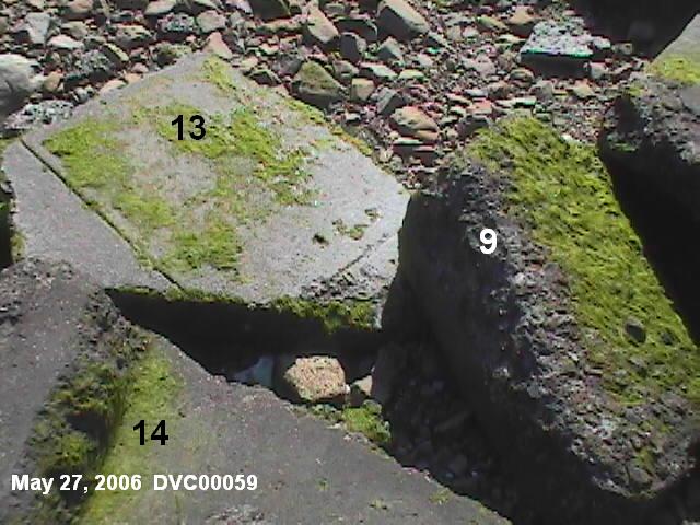


Laci wasn't just laying on rock 13. She was at the back of rock 13, with her left leg wedged between rock 14 and rock 9. In addition, the water level has to be deep enough for her bones to clear rock 17 and come to rest on its top. Her position definitely has to be considered when answering the question, Did Laci wash ashore?
On my May 27, 2006 trip, I quickly noted that the rocks are very slippery when wet, especially the mossy areas, and the rocks involved were nearly entirely covered with moss. This suggests that once her body was on top of rock 13, the force of the waves would simply slide her to the back, to rest against rock #14.
However, a video I had occasion to take of a dead animal shows that the slippery rocks can also make it more difficult for the waves to bank a body on a rock, as the body merely slides back off. I recommend viewing the Media Player version, for its higher quality. Also decreasing the size of the viewing screen sharpens the video.
Media Player dead animal Real Player dead animal
Water levels and wind conditions on April 13-14, 2003
On the morning of April
14, 2003, Alena Gonzalez and her group arrived about
11:10-11:15 a.m. It's unclear whether they found Laci at
11:45 or that's when she made the call to report the
discovery. She described Laci's body as "half submerged
in the water . . . there in the water, and the water was
splashing up on her." Another dog had already found Laci
and was chewing on Laci's elbow. Laci's body was also
described as "wedged in the rocks."
This chart shows the previous high tides, going back to
the storm on the 12th. Water level is feet above
MLLW. The winds are given for the UC Richmond
station and the LA Times report for the Oakland Airport. The On Shore
column is the length of time Laci's body would have been
on the shore before being found, if she washed up in
that tide.
| DATE | TIME | WATER LEVEL | UC Richmond | LA Times Wind | On Shore |
| April 14 | 10:30 a.m. | 5.78 feet | 5 mph | 6.9 mph | 1 hour |
| April 13 | 11:06 p.m. | 5.68 feet | 3 mph | 5.8 mph | 12 1/2 hours |
| April 13 | 10:06 a.m. | 5.88 feet | 14 mph, G 23 | 13.8 mph | 1 day |
| April 12 | 10:42 p.m. | 5.58 feet | 13 mph, G 24 | 11-13 mph | 1 1/2 days |
| April 12 | 8:24 a.m. | 5.77 feet | 20 mph, G 32 | 30 mph, G 36 | 2 days |
For the first two tides, the wind would not have been a factor in washing Laci ashore on the morning of April 14, 2003. This video shows how gentle the waves are at those speeds. The water level is from 5.63 feet [corrected to 5.75] to 4.93 feet [corrected to 5.02] WindowsMedia RealPlayer [See December 13, 2005 Field Trip for explanation of the correction]
Wave action could have been a factor in the other 3 tides. Video taken on May 27, 2006 shows the effects of the stronger wave action, but we have the burden of explaining why her body was so long on the shore without being discovered.
Media Player Laci Site Real Player Laci Site
The Prosecution opted to assume she washed ashore in the April 14, 10:30 a.m. tide, and made no effort to prove otherwise.
Pictures and video taken on our field trips are not nearly as conclusive as for Conner. On December 13, the water level wasn't quite as high as on the April 14 high tide, but the wind was comparable. On May 27, the water level was lower than on April 14, but the winds were stronger.
The Low Tides on April 13-14, 2003
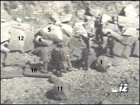
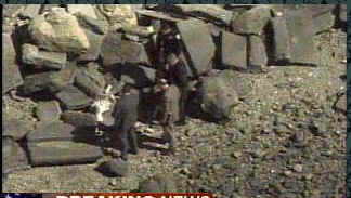
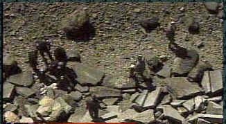
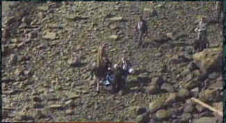
We do know that she didn't have to wash ashore. She could have been carried to where she was and left there, just as Conner was. The first picture is taken of the men looking down to where Laci was found, with no water in sight -- but which presents a formidable descent carrying a dead body. You can see in the next two pictures that several men are walking around the area on dry ground and in the 4th picture the men are carrying Laci to the south before bringing her up the slope in picture 5, a much easier climb than up the rocks. You can see the slope's location relative to Laci's body in picture 6. This obviously would be a much easier route to bring her to her resting place, than trying to descend those rocks.
The times indicated on the first two pictures are 6:03 and 5:01 p.m. At 5:00 the low tide bottomed out at .05 feet above MLLW. By 6:03 p.m., the rising tide had increased the water level to .51 feet above MLLW.
Laci was found at a little after 11 a.m. on the 14th. The previous low tide was at 4:54 a.m., with a water level of 1.41 feet, sufficiently low to allow access to where Laci was found, going down the same embankment they used to bring her up. The next previous low tide was at 4:30 p.m. on the 13th. It's not likely that anyone would attempt to place her body during broad daylight, so that low tide is eliminated as a possibility.
| DATE | TIME | WATER LEVEL | On Shore |
| April 14 | 10:30 a.m. | 5.78 feet | 1 hour |
| April 14 | 4:54 a.m. | 1.41 feet | 6 1/2 hours |
| April 13 | 11:06 p.m. | 5.68 feet | 12 1/2 hours |
| April 13 | 4:30 p.m. | .11 feet | |
| April 13 | 10:06 a.m. | 5.88 feet | 1 day |
| April 13 | 3:48 a.m. | 2.38 feet | |
| April 12 | 10:42 p.m. | 5.58 feet | 1 1/2 days |
| April 12 | 8:24 a.m. | 5.77 feet | 2 days |
The next previous low tide was at 2.38 feet above MLLW during the early morning hours of April 13. We can't say for certain whether that water level was sufficiently low to allow dry-ground access to where Laci was found because we have not viewed the site at that water level. The water level for these pictures was still over 3 1/2 feet above MLLW and you can see that the water has receded considerably.
The evidence taken so far does not prove or disprove Laci washing ashore. However, we believe that the more likely scenario is that Laci was put into the Hoffman Channel during ebb tide during the night of April 12/13, expecting that she would wash ashore nearby. When her body didn't surface with the high tide on the morning of the 13th, Conner was placed on the Jetty so he would be found in a way that would not risk his body also being lost. Then, unexpectedly, Laci did wash ashore on the morning of the 14th.